PROPER DISPOSAL OF TRASH
Trash bins will be placed approximately 50 meters down the course from each aid station. It is your responsibility to hang onto your trash (including gel packets) until it can be properly disposed.
Cleaning up after ourselves is of paramount importance, not just because its the law, but its also the right thing to do. After all, for most of the run well be enjoying some beautiful scenery that should at all costs be preserved for future generations.
Please - dont litter. We really dont want to have to disqualify anyone and possibly bar them from future entry. After all, we believe that if one is tough enough to run a marathon, one should be strong enough to carry a gel packet until the next trash bin. Lets be kind and leave only our footprints behind.
THE COURSE (Click HERE for a USATF course map)
Jonas Ridge to Brown Mountain Beach Resort (Caldwell County, NC). The course starts on Mortimer Road in front of the U.S. Post office, diagonally across NC181 from and Mountain Crossing Mercantile. Starting from the Post Office:
· Follow Mortimer Road, bearing left at Old Jonas Ridge Road (approx 2.5 miles into the run);
· Continue on Old Jonas Ridge until turnaround located approximately 25 meters before the stop sign for the Blue Ridge Parkway;
· Turn back toward the start, bearing left onto the unpaved rad just beyond the white Chuch on your left (approx. 5.5 miles into the run);
· Follow the unpaved road toward Edgemont, turning left onto Edgemont Rd (approx. 14.5 miles into run);
· Follow Edgemont Road north through Edgemont, approximately 250 meters beyond Coffeys General Store to turnaround (approx. 15.5 miles into run);
· Turn back (south) on Edgemont Road to Mortimer. Turn right onto Brown Mountain Beach Road (approx. 18 miles into run);
· Follow Brown Mountain Beach Road for approximately 8 miles;
· Turn right into Brown Mountain Beach Resort to the finish line.
All distances and reference markers noted above are approximate; actual reference marker locations are available on the USATF web site under certified courses. In the meantime, please click here for a link to the course map as submitted and incorporated into the USATF Measurement Certificate. On the map you can clearly find the start, finish, and both out & back locations. The mile markers are referenced on another document which is probably a bit bulky to be posted here but you'll get the general idea. Mile markers will be clearly identified with high visibility signs on race day, as will all of the turns, so we're pretty confident no one will get lost.
DIRECTIONS TO PARKING & BUS PICKUP (The marathon finish line is located here!) -- GPS 35.9067° N, 81.7248° W
The following directions were lifted from the Brown Mountain Beach Resort web site . You may want to visit the web site yourself just to get a preview of what the area looks like. The physical address there is 6785 Brown Mountain Beach Rd., Collettsville NC 28611
Using Interstate 40 West (from Statesville):
·Take Morganton exit 100 and go right onto Jamestown Rd.
·Follow Jamestown Rd until it tees into NC181 (Hardees will be on your right). Turn LEFT.
·Travel 10.2 miles and turn right onto Brown Mountain Beach Rd.
·Travel 5 miles and turn left after concrete bridge onto Brown Mountain Beach Rd.
·Resort is 3/4 mile on left
Using I-85 South/US-321 North/I-40 West (from Charlotte):
·Take I-85 South toward Gastonia/Spartanburg
·Take Exit 17 for US-321 North toward Gastonia/Lincolnton
·Follow US-321 to Exit 43B for I-40 West, toward Asheville
·Take Morganton exit 100 and go right onto Jamestown Rd.
·Follow Jamestown Rd until it tees into NC181 (Hardees will be on your right). Turn LEFT.
·Travel 10.2 miles and turn right onto Brown Mountain Beach Rd.
·Travel 5 miles and turn left after concrete bridge onto Brown Mountain Beach Rd.
·Resort is 3/4 mile on left
Using Interstate 40 East (from Asheville):
·Take Morganton exit 100 and go left onto Jamestown Rd.
·Follow Jamestown Rd until it tees into NC181 (Hardees will be on your right). Turn LEFT.
·Travel 10.2 miles and turn right onto Brown Mountain Beach Rd.
·Travel 5 miles and turn left after concrete bridge onto Brown Mountain Beach Rd.
·Resort is 3/4 mile on left
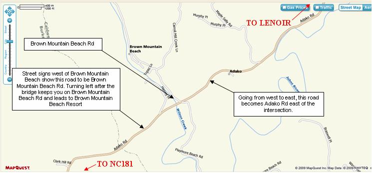
Signs will be posted at the turn to Brown Mountain Beach Rd and to provide directions to the parking area. PLEASE NOTE: Brown Mountain Beach Rd turns into Adako Rd (going from west to east) at the turn-off to Brown Mountain Beach Resort. The turn-off itself is also called Brown Mountain Beach Rd, heading north from the intersection. Please see the map below:
The following directions were lifted from the Brown Mountain Beach Resort web site . You may want to visit the web site yourself just to get a preview of what the area looks like. The physical address there is 6785 Brown Mountain Beach Rd., Collettsville NC 28611
Using Interstate 40 West (from Statesville):
·Take Morganton exit 100 and go right onto Jamestown Rd.
·Follow Jamestown Rd until it tees into NC181 (Hardees will be on your right). Turn LEFT.
·Travel 10.2 miles and turn right onto Brown Mountain Beach Rd.
·Travel 5 miles and turn left after concrete bridge onto Brown Mountain Beach Rd.
·Resort is 3/4 mile on left
Using I-85 South/US-321 North/I-40 West (from Charlotte):
·Take I-85 South toward Gastonia/Spartanburg
·Take Exit 17 for US-321 North toward Gastonia/Lincolnton
·Follow US-321 to Exit 43B for I-40 West, toward Asheville
·Take Morganton exit 100 and go right onto Jamestown Rd.
·Follow Jamestown Rd until it tees into NC181 (Hardees will be on your right). Turn LEFT.
·Travel 10.2 miles and turn right onto Brown Mountain Beach Rd.
·Travel 5 miles and turn left after concrete bridge onto Brown Mountain Beach Rd.
·Resort is 3/4 mile on left
Using Interstate 40 East (from Asheville):
·Take Morganton exit 100 and go left onto Jamestown Rd.
·Follow Jamestown Rd until it tees into NC181 (Hardees will be on your right). Turn LEFT.
·Travel 10.2 miles and turn right onto Brown Mountain Beach Rd.
·Travel 5 miles and turn left after concrete bridge onto Brown Mountain Beach Rd.
·Resort is 3/4 mile on left
Signs will be posted at the turn to Brown Mountain Beach Rd and to provide directions to the parking area. PLEASE NOTE: Brown Mountain Beach Rd turns into Adako Rd (going from west to east) at the turn-off to Brown Mountain Beach Resort. The turn-off itself is also called Brown Mountain Beach Rd, heading north from the intersection. Please see the map below:
REGISTRATION PROCESS
Registration will be conducted on a first-come, first served basis on RunSignUp. Links to the registration site are available in this section of the website. Just click on the giant RunSignUp logo below and you'll be taken there to register:
Registration will be conducted on a first-come, first served basis on RunSignUp. Links to the registration site are available in this section of the website. Just click on the giant RunSignUp logo below and you'll be taken there to register:
COURSE RECORDS
Male Open: Tomasz Kochanowicz, 2:39:13 (2012)
Female Open: Tracy Brooks, 2:53:12 (2011)
Male Masters: Michael Dwomoh, 2:41:47 (2014)
Female Masters: Jennifer Bodnar, 3:06:57 (2018)
Male Open: Tomasz Kochanowicz, 2:39:13 (2012)
Female Open: Tracy Brooks, 2:53:12 (2011)
Male Masters: Michael Dwomoh, 2:41:47 (2014)
Female Masters: Jennifer Bodnar, 3:06:57 (2018)
GENERAL INFORMATION (Revised 03/17/2019)
|
|
|
|
|


Copyright 2006-2019 Finish Line Pros. All rights reserved.
Want to learn more and see more photos of the area? Click here to visit the Friends of Wilson Creek web site.
|
|
|


Runners will park at Brown Mountain Beach Resort near the finish line BEFORE the race starts.
Buses will pick runners up at Brown Mountain Beach Resort and take them to the start in Jonas Ridge (Don't forget your keys!)
Runners reclaim their vehicles right where they left them after finishing the race.
PARKING & SHUTTLE SUMMARY
Peak to Creek Marathon 2019
Jonas Ridge to Brown Mountain Beach, NC • Saturday, October 26, 2019 • 8:00am
The Peak to Creek Marathon course is USATF certified (certificate NC09064-PH). Qualifying times achieved in this race will be eligible for submittal to the BAA for admission into the Boston Marathon.
This information is considered complete and up-to-date as of the date of this writing. As with the best-laid plans of any endeavor, however, it is possible that some details can change. Please check back to this site often for the most current information. You are most strongly encouraged to take one final look on Wednesday, October 23rd, as we plan to go with whatever weve got at that time.
Back again for 2019!
Just as it has since 2014, the Peak to Creek Marathon, formerly known as the Ridge to Bridge Marathon, is hosted by Burke Recovery, whose mission is to "...work collaboratively with community partners to provide education/prevention, treatment and recovery support services to all citizens of Burke County, regardless of their ability to pay." All proceeds of this event will benefit Burke Recovery in its mission to help create healthier lives.
Just as it has since 2014, the Peak to Creek Marathon, formerly known as the Ridge to Bridge Marathon, is hosted by Burke Recovery, whose mission is to "...work collaboratively with community partners to provide education/prevention, treatment and recovery support services to all citizens of Burke County, regardless of their ability to pay." All proceeds of this event will benefit Burke Recovery in its mission to help create healthier lives.
What's with the name change? (in case you missed it before now...)
When the course was re-designed for the 2009 Ridge to Bridge Marathon there was no longer a bridge anywhere near the finish. We left the name as it was anyway. Now that the event has a new host, we thought this would be a great time to change the name as well; "Peak to Creek" better reflects the course, which starts at the upper elevations of northwestern Burke County (the "peak") and finishes some 2,800 feet lower at Wilson Creek.
When the course was re-designed for the 2009 Ridge to Bridge Marathon there was no longer a bridge anywhere near the finish. We left the name as it was anyway. Now that the event has a new host, we thought this would be a great time to change the name as well; "Peak to Creek" better reflects the course, which starts at the upper elevations of northwestern Burke County (the "peak") and finishes some 2,800 feet lower at Wilson Creek.
Meet your Race Directors
David & Rhonda Lee, co-directors of the marathon since its inception in 2006, will continue to guide the event assisted by the enormous energy and talent of Burke Recovery's Board, staff, and volunteers. P2CM19 (our 14th running) will be our best ever!
David & Rhonda Lee, co-directors of the marathon since its inception in 2006, will continue to guide the event assisted by the enormous energy and talent of Burke Recovery's Board, staff, and volunteers. P2CM19 (our 14th running) will be our best ever!
WELCOME!
Veteran P2CM'ers and newcomers who joined the Peak to Creek family in 2018 were treated to a cool day on a beautiful course that passes through the Pisgah National Forest. If you've been here before, it'll be good to have you back. If this would be your first time with us, we would like to take this opportunity to offer a warm welcome. We think you'll like our marathon, and love the National Forest!
Veteran P2CM'ers and newcomers who joined the Peak to Creek family in 2018 were treated to a cool day on a beautiful course that passes through the Pisgah National Forest. If you've been here before, it'll be good to have you back. If this would be your first time with us, we would like to take this opportunity to offer a warm welcome. We think you'll like our marathon, and love the National Forest!
CHAMPIONCHIP TIMING & SCORING
Finish Line Pros (Morganton, NC) will be on-hand to provide net (chip start & finish) chip timing using ChampionChip timing. The timing chips will be single use chips, which means no post-race collection. Your chip is yours to keep as a souvenir. ChampionChip timing chips are worn on the shoe, for more accurate and reliable reads. Instructions for the proper use of a ChampionChip timing chip will be included in your race packet. Failure to follow these instructions may result in no time being reported for you at the finish! Awards will be based on gun times in accordance with USATF rules. Net (chip) times will be reported to the Boston Athletic Association.
Finish Line Pros (Morganton, NC) will be on-hand to provide net (chip start & finish) chip timing using ChampionChip timing. The timing chips will be single use chips, which means no post-race collection. Your chip is yours to keep as a souvenir. ChampionChip timing chips are worn on the shoe, for more accurate and reliable reads. Instructions for the proper use of a ChampionChip timing chip will be included in your race packet. Failure to follow these instructions may result in no time being reported for you at the finish! Awards will be based on gun times in accordance with USATF rules. Net (chip) times will be reported to the Boston Athletic Association.
DATE & TIME
Saturday, October 26, 2019, 8:00am
The course limit is six (6) hours so please come prepared to cross the finish line by 2:00pm. This means a very long day for some of our volunteers. Let's be kind and finish up so they can go home.
Saturday, October 26, 2019, 8:00am
The course limit is six (6) hours so please come prepared to cross the finish line by 2:00pm. This means a very long day for some of our volunteers. Let's be kind and finish up so they can go home.
THE FIELD
To the folks who bring you the Peak to Creek Marathon, two things stand out as the most important: your safety and the quality of your experience here with us, in that order. To keep you safe and happy, and to comply with the legal limit for the number of participants who can participate in this event, the U.S. Forest Service has placed a strict limit of 400 runners on our field. We don't have any wiggle room on this; the law is the law. Once we reach 400 registrations (not 401 or 450, knowing that there will be no-shows on race day) we'll automatically go into wait list mode. Our best guess is that the race will sell out within the first week. It has filled in as little as 20 minutes so be prepared when 12:00pm (eastern time) on May 1st arrives.
To the folks who bring you the Peak to Creek Marathon, two things stand out as the most important: your safety and the quality of your experience here with us, in that order. To keep you safe and happy, and to comply with the legal limit for the number of participants who can participate in this event, the U.S. Forest Service has placed a strict limit of 400 runners on our field. We don't have any wiggle room on this; the law is the law. Once we reach 400 registrations (not 401 or 450, knowing that there will be no-shows on race day) we'll automatically go into wait list mode. Our best guess is that the race will sell out within the first week. It has filled in as little as 20 minutes so be prepared when 12:00pm (eastern time) on May 1st arrives.
ENTRY FEE SCHEDULE
Given that this race usually sells out not too long after registration opens it wouldn't make sense to offer an escalating entry fee schedule with cut-off dates. This also tends to penalize wait-listers unfairly, since they have no control over when they receive an invitation to come back to the site to claim a newly-opened slot. Your entry fee includes parking at Brown Mountain Beach Resort, transportation to the start, and lunch when you finish the race.
May 1st through October 20th - $110.00
WITHDRAWALS & REFUNDS (Available through October 13, 2019)
Runners who register for the 2019 Peak to Creek Marathon may withdraw at any time, for any reason, up to October 13, 2019 and receive a refund of 50% of the base entry fee paid (separate from the online registration convenience fee, which is non-refundable). We are sorry, but refunds will not be available after October 13, and entries paid in 2019 may not be deferred until 2020. The withdrawal process is simple, and can be done by visiting the online registration site and following the instructions. There is no need to notify anyone that you are withdrawing; the online registration site will take care of it. Refund checks will be sent by mail directly by RunSignUp. Instructions for withdrawing on RunSignUp can be viewed here: https://runsignup.com/How-To/Request-A-Refund. Direct bib-transfers, swaps, or outright sales to third parties are not permitted. Let's be fair to those who wait patiently on the Wait List and ensure that the next person in line gets the next available opening.
Runners who register for the 2019 Peak to Creek Marathon may withdraw at any time, for any reason, up to October 13, 2019 and receive a refund of 50% of the base entry fee paid (separate from the online registration convenience fee, which is non-refundable). We are sorry, but refunds will not be available after October 13, and entries paid in 2019 may not be deferred until 2020. The withdrawal process is simple, and can be done by visiting the online registration site and following the instructions. There is no need to notify anyone that you are withdrawing; the online registration site will take care of it. Refund checks will be sent by mail directly by RunSignUp. Instructions for withdrawing on RunSignUp can be viewed here: https://runsignup.com/How-To/Request-A-Refund. Direct bib-transfers, swaps, or outright sales to third parties are not permitted. Let's be fair to those who wait patiently on the Wait List and ensure that the next person in line gets the next available opening.
WAIT LIST
Just as we did in past years, once the race is full, runners can self-register for the waiting list. As runners withdraw, wait listers are notified by email and given two (2) days to come to the web site and claim the spot by completing their registration. You are responsible for monitoring your email for notices from RunSignUp; if you miss your email (or it lands in your spam box) and your invitation expires, you'll have to start the process over again from the back of the line.
No fees will be charged to sign up for the waiting list; entry fees are charged only as runners are invited to complete registration.
WEATHER CONDITIONS
Sunrise: 7:32am Avg. High: 67°F Avg. Low: 39°F Record High: 84°F Record Low: 24°F
The averages and records listed above are for the Morganton/Lenoir area, which is where the finish line is located. Be aware that the October 27th average low for the Jonas Ridge area is 34°F; the record low is 17°F. In other words, on the average October 26th you can expect a temperature of 34°F at the starting line and 67°F at the finish line.
The temps over the last several years have stayed more or less in this window, although it has been a bit cooler at the start one year, and a bit warmer at the finish another. Weve also experienced some wind and some rain but, all in all, weve not yet experienced a really miserable weather day for a marathon. Maybe were overdue? Just remember that this marathon takes place in the Blue Ridge Mountains and southern foothills of North Carolina in late October. Virtually anything is possible, so pack accordingly.
PACKET PICKUP
Race packets may be picked up on Friday at Bridgeway Solutions (600 East Union Street, Morganton) or at the starting line between 7:00AM and 7:40AM race day. Friday packet pickup will take place from 5:30pm to 9:00pm at Bridgeway Solutions. Please note that this is a place of business that will be open until 5:00pm on the day of packet pickup, so please do not arrive before 5:30pm. Folks choosing to ignore this request will likely be given the official stink eye from the co-race director and may find his or her published finish time has an extra hour tacked onto it (the co-race director also happens to be the timer).
Parking is limited so carpooling to packet pickup on Friday night is recommended. If you plan to come by yourself, please plan to run in, grab your stuff, and depart so the next group can come in. We'll have plenty of time to chit-chat after the race.
Race day packets must be picked up before 7:45AM or yours may not be there when you get there. Please make sure you arrive on time so we can get started promptly at 8:00AM. If you arrive at 7:55AM and your packet is no longer there, please understand that we have to be fair to those who picked up on time and wish to get the race under way. NOTE: Shirts will NOT be handed out at the start on race day. Packets picked up on race day will include your timing chip and race bib only. Your shirt will be available at the finish area!
FOR YOU PROCRASTINATORS/OPTIMISTS: In-person registration may be available at packet pickup on Friday night. If the race hasn't already filled, the price of last-minute entry will be the same as shown above.
HOST HOTEL
All of the construction work along South Sterling Street near I-40 Exit 105 is behind us, so those of you who choose to stay in this area will find smoother sailing. We do not designate a host hotel, so you're on your own to choose the one that best meets your needs and budget. We encourage you to book early as the better properties fill fast once registration opens up. Remember that you're also competing for hotel space with tourists who come to town to look at the fall foliage. Can't say we blame them.
Hotel options in Morganton can be found by following this link. Our $0.02 worth on this one: stick with the brand names. If hotel space in Morganton is no longer available when it comes time for you to make your reservation, we recommend Lenoir, NC as the next closest option. It's no further than Morganton to either the finish or the start.
PARKING & BUS DEPARTURE FOR THIS POINT-TO-POINT COURSE -- GPS 35.9067° N, 81.7248° W
Runners will park near Brown Mountain Beach Resort, which is located about 45 minutes from Morganton and Lenoir. Due to a shortage of parking in Jonas Ridge we strongly recommend parking in the designated area at Brown Mountain Beach and making use of the transportation provided. Buses will leave promptly at 6:30am and arrive in Jonas Ridge at ~7:15am. The race will start promptly at 8:00am. The finish line is approximately 300 meters from the parking area.
Runners are encouraged to arrive at the bus pickup area by 6:00am to allow sufficient time for last-minute preparation and boarding the buses. Allow 45 minutes travel time by car from either Morganton or Lenoir.
THE START (Get directions to the Start)
The Peak to Creek Marathon will be timed using net chip timing, which means we will record a start time and finish time for all competitors. This means that the time it takes you to get to the starting line will be deducted from the time it takes you to finish. Having said that, awards will be presented based on gun times, in accordance with USA Track & Field rules. To minimize congestion and delay at the start for those who have come with PR's in mind we will encourage those who come with a less aggressive goal in mind to line up further from the starting line.
The Peak to Creek Marathon will be timed using net chip timing, which means we will record a start time and finish time for all competitors. This means that the time it takes you to get to the starting line will be deducted from the time it takes you to finish. Having said that, awards will be presented based on gun times, in accordance with USA Track & Field rules. To minimize congestion and delay at the start for those who have come with PR's in mind we will encourage those who come with a less aggressive goal in mind to line up further from the starting line.
COURSE PROFILE
The Peak to Creek course consists of approximately 7 miles of paved surface: approximately 5.5 miles at the start in Jonas Ridge, and a few short stretches in various places along the course, including the last quarter mile or so. Ancestral R2BM veterans will see the map below and notice some enormous differences, especially the noticeable lack of significant hills on the back half.
The majority of the course is run on quiet, unpaved country roads that pass through dense forests and open fields, and provide for some outstanding views of the mountains. Camber is not an issue.
The course is not a trail, in any sense of the word, but simply an unpaved road. There can be rocks and sticks that may have fallen from overhanging trees, but there will be no large stones or roots lying in wait to catch the shuffling foot. If you are not accustomed to running downhill on an unpaved surface and you plan to run aggressively, we urge you to be especially careful when negotiating turns. There may be some loose stones in some places and it may be possible to slip if youre not paying attention to what youre doing.
The bottom line: be aware of whats on the course that you might step on, especially as youre entering a turn running downhill. You may just avoid a nasty scrape or two.
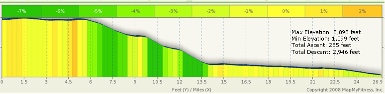
The hills on the new course are fewer in number and tend to be less steep, none with a grade of greater than 2%. They also tend to be front-end loaded, with the more noticeable rises appearing within the first 1.5 miles (~ 20 meters of climb over the distance), and from mile 4.7 - 5.6 (~ 15.5 meters). Further along the course, you may expect two more modest rises: mile 9.6 - 9.8 (~ 3 meters) and mile 15.0 - 15.7 (~ 7.5 meters); and a bump in the road at mile 21.7 - 21.9 (~ 2 meters).
All of these little rises can be quickly identified on the profile map (below) as gold and orange vertical bands. For example, the orange vertical band that appears just to the right of the 4.5 mark on the X-axis correlates with the roughly 15.5 meters of climb between mile 4.7 and mile 5.6. It also happens to be the only orange vertical band on the graph, indicating that at a 2% grade, it is the steepest section on the course. To put this into context, Zion Hill on the old Ridge to Bridge course climbs approximately 300 feet over a space of just over a mile with 4-5% grades over the span.
A quick glance at the yellow, light green, and dark green vertical bands reveals how much of the course is either flat or descending; the darker the green, the steeper the descent.
The Peak to Creek course consists of approximately 7 miles of paved surface: approximately 5.5 miles at the start in Jonas Ridge, and a few short stretches in various places along the course, including the last quarter mile or so. Ancestral R2BM veterans will see the map below and notice some enormous differences, especially the noticeable lack of significant hills on the back half.
The majority of the course is run on quiet, unpaved country roads that pass through dense forests and open fields, and provide for some outstanding views of the mountains. Camber is not an issue.
The course is not a trail, in any sense of the word, but simply an unpaved road. There can be rocks and sticks that may have fallen from overhanging trees, but there will be no large stones or roots lying in wait to catch the shuffling foot. If you are not accustomed to running downhill on an unpaved surface and you plan to run aggressively, we urge you to be especially careful when negotiating turns. There may be some loose stones in some places and it may be possible to slip if youre not paying attention to what youre doing.
The bottom line: be aware of whats on the course that you might step on, especially as youre entering a turn running downhill. You may just avoid a nasty scrape or two.
The hills on the new course are fewer in number and tend to be less steep, none with a grade of greater than 2%. They also tend to be front-end loaded, with the more noticeable rises appearing within the first 1.5 miles (~ 20 meters of climb over the distance), and from mile 4.7 - 5.6 (~ 15.5 meters). Further along the course, you may expect two more modest rises: mile 9.6 - 9.8 (~ 3 meters) and mile 15.0 - 15.7 (~ 7.5 meters); and a bump in the road at mile 21.7 - 21.9 (~ 2 meters).
All of these little rises can be quickly identified on the profile map (below) as gold and orange vertical bands. For example, the orange vertical band that appears just to the right of the 4.5 mark on the X-axis correlates with the roughly 15.5 meters of climb between mile 4.7 and mile 5.6. It also happens to be the only orange vertical band on the graph, indicating that at a 2% grade, it is the steepest section on the course. To put this into context, Zion Hill on the old Ridge to Bridge course climbs approximately 300 feet over a space of just over a mile with 4-5% grades over the span.
A quick glance at the yellow, light green, and dark green vertical bands reveals how much of the course is either flat or descending; the darker the green, the steeper the descent.
TRAFFIC CONDITIONS
Traffic on Saturday mornings at 8:00am in Jonas Ridge, NC is usually very light. Its possible well see a handful of cars over the first 5.5 miles, after which we might see another dozen or so on the way to Brown Mountain Beach Resort. None of the roads we will be using will be closed on race day; we will share them with the small number of cars were likely to encounter along the way. Please be courteous: smile, wave, and then get out of the way. Do not run left of the center line; be safe and stay to the right of the roadway. Any runner who fails to yield the proper right of way to vehicles may be disqualified. This is non-negotiable; cars & trucks weigh a lot more than runners and require a lot more room to stop. Play it safe: stay to the right and remain aware of your surroundings at all times.
Traffic on Saturday mornings at 8:00am in Jonas Ridge, NC is usually very light. Its possible well see a handful of cars over the first 5.5 miles, after which we might see another dozen or so on the way to Brown Mountain Beach Resort. None of the roads we will be using will be closed on race day; we will share them with the small number of cars were likely to encounter along the way. Please be courteous: smile, wave, and then get out of the way. Do not run left of the center line; be safe and stay to the right of the roadway. Any runner who fails to yield the proper right of way to vehicles may be disqualified. This is non-negotiable; cars & trucks weigh a lot more than runners and require a lot more room to stop. Play it safe: stay to the right and remain aware of your surroundings at all times.
COURSE SURFACE
Please allow these photos to end any speculation as to whether or not the Peak to Creek Marathon course resembles a trail. And as long as Im adding some photos, Ill include some extras so you can familiarize yourself with some of the scenery ahead of time. (NOTE: none of the photos were taken in the fall, so use your imagination!) Click on each photo for a larger view.
Please allow these photos to end any speculation as to whether or not the Peak to Creek Marathon course resembles a trail. And as long as Im adding some photos, Ill include some extras so you can familiarize yourself with some of the scenery ahead of time. (NOTE: none of the photos were taken in the fall, so use your imagination!) Click on each photo for a larger view.
HEAD PHONES
As many of you know, USATF changed its stance on head phones earlier in 2009. Many events, including this one, no longer enforce a ban on their use.
Having said that, we are obliged to ask you to consider this: one cannot avoid what one cannot see or hear. Not wearing head phones (or only listening to one ear bud) is safer for you and more courteous to your fellow runners. PLEASE REMOVE YOUR EARPIECES BEFORE ENTERING THE FINISH AREA!
AID STATIONS
Aid stations will be stocked with water and sports drink at the following approximate locations along the course: Mile 2.4; 5.7 (same location as 2.4); 8.25; 11.25; 13.1; 15/16 (same location); 18.5; 21; 23.2; and 25. Although we used to stock some of our aid stations with energy gels, we've learned that folks can be pretty particular in their choice of brand and flavor. For this reason we will no longer have large quantities on hand; a small number may be available at the later stages for 'emergencies.' If you rely on gels to get through the race, please bring your own. A reminder: if you bring them in, be sure to carry them out. Don't litter!
Aid stations will be stocked with water and sports drink at the following approximate locations along the course: Mile 2.4; 5.7 (same location as 2.4); 8.25; 11.25; 13.1; 15/16 (same location); 18.5; 21; 23.2; and 25. Although we used to stock some of our aid stations with energy gels, we've learned that folks can be pretty particular in their choice of brand and flavor. For this reason we will no longer have large quantities on hand; a small number may be available at the later stages for 'emergencies.' If you rely on gels to get through the race, please bring your own. A reminder: if you bring them in, be sure to carry them out. Don't litter!
LOST & FOUND
Extra articles of clothing you'd like to shed may be left with us at the start or at the Mile 2.4/5.7 Aid Station. These articles will be taken to the finish area for pickup when you arrive, or shortly thereafter. Articles left at other aid stations will also be taken to the finish area but may or may not be available when you get there. If you leave something with us you'd like to have back, please stay until the volunteers from that aid station arrive. Articles not collected before we leave for the day (approximately 2:30pm) will be donated to a suitable charity if not claimed with 7 days of the race. Please be prepared to pick your things up in-person; articles will not be mailed.
Extra articles of clothing you'd like to shed may be left with us at the start or at the Mile 2.4/5.7 Aid Station. These articles will be taken to the finish area for pickup when you arrive, or shortly thereafter. Articles left at other aid stations will also be taken to the finish area but may or may not be available when you get there. If you leave something with us you'd like to have back, please stay until the volunteers from that aid station arrive. Articles not collected before we leave for the day (approximately 2:30pm) will be donated to a suitable charity if not claimed with 7 days of the race. Please be prepared to pick your things up in-person; articles will not be mailed.
TOILETS
Restroom facilities will be available at the start and finish. Given the remote nature of the course, most of it on National Forest property, it's just not practical (or proper) to place unsightly porta-jons everywhere. Fixed facilities are also available at Mortimer Campground (~ mile 18) and the Visitor Center (~ mile 21). Plan your Friday night food intake accordingly.
Restroom facilities will be available at the start and finish. Given the remote nature of the course, most of it on National Forest property, it's just not practical (or proper) to place unsightly porta-jons everywhere. Fixed facilities are also available at Mortimer Campground (~ mile 18) and the Visitor Center (~ mile 21). Plan your Friday night food intake accordingly.
AWARDS
Awards will be presented to the top three overall males and females, top male and female masters (40+), and the top three males and females in each of the following age groups: 19 and under; 20-24; 25-29; 30-34; 35-39; 40-44; 45-49; 50-54; 55-59; 60-64; 65-69; 70-74; and 75 & over. Award winners must be present at the awards ceremony; no prizes will be sent by mail (no exceptions, sorry). Enjoy the post-race food-fest during the presentation of awards!
Awards will be presented to the top three overall males and females, top male and female masters (40+), and the top three males and females in each of the following age groups: 19 and under; 20-24; 25-29; 30-34; 35-39; 40-44; 45-49; 50-54; 55-59; 60-64; 65-69; 70-74; and 75 & over. Award winners must be present at the awards ceremony; no prizes will be sent by mail (no exceptions, sorry). Enjoy the post-race food-fest during the presentation of awards!
RUNNERS' SHIRTS & FINISHERS' MEDALS
Long sleeve technical shirts and Peak to Creek 2019 medallions will be presented at the finish line to everyone who completes the full distance. Shirts are unisex and run more or less true to size.
Long sleeve technical shirts and Peak to Creek 2019 medallions will be presented at the finish line to everyone who completes the full distance. Shirts are unisex and run more or less true to size.
DROPPING OUT OF THE RACE
Everyone has a bad day now and then, and flying down a 2,700 foot descent increases the chances that October 26th might be your bad day (although we hope not!). If you find yourself more uncomfortable than youre accustomed to in a marathon we encourage you to think carefully about whether or not you really ought to continue. Wed much rather see you pull out before a serious injury so that you will be in a better position to join us again next year. Please, dont hurt yourself; one race simply isnt worth it. Well see to it that you have a ride back to your car.
Everyone has a bad day now and then, and flying down a 2,700 foot descent increases the chances that October 26th might be your bad day (although we hope not!). If you find yourself more uncomfortable than youre accustomed to in a marathon we encourage you to think carefully about whether or not you really ought to continue. Wed much rather see you pull out before a serious injury so that you will be in a better position to join us again next year. Please, dont hurt yourself; one race simply isnt worth it. Well see to it that you have a ride back to your car.
A WORD REGARDING RACE BANDITS
Most runners will agree that the practice of participating in a race for which you have neither entered nor paid the entry fee is inherently discourteous to those who have. Please -- if you havent registered please do not take for yourself that which others have paid for. If you havent registered but you still really want to get in on the marathon experience, please contact the Race Director and offer your services as a volunteer; wed be glad to have your help!
Most runners will agree that the practice of participating in a race for which you have neither entered nor paid the entry fee is inherently discourteous to those who have. Please -- if you havent registered please do not take for yourself that which others have paid for. If you havent registered but you still really want to get in on the marathon experience, please contact the Race Director and offer your services as a volunteer; wed be glad to have your help!
A FINAL THOUGHT REGARDING RACE STRATEGY
There is no such thing as a gimme marathon course. 26.2 miles is a long way to run no matter how the course is laid out. Please accept this advice from those who really, really want to see you do well.
The first 10 kilometers of the course might best be described as a rolling 10K. Much of it is flat or slightly downhill, while there are some sections (the first 1.5 miles, 3.6-3.8, and 4.7-5.6) that offer modest climbs. As noted in the COURSE PROFILE section, 4.7-5.6 may well be the steepest grade on the course. The best use of this upper section is to establish a comfortable pace and take advantage of the warm-up to be better prepared to start the descent toward Edgemont.
The nine miles between Mortimer Road and Edgemont Road offer the longest, sustained downhill sections on the course. Although one might be tempted to put some time in the bank by flying down the hill, it is far better to take a more conservative approach. A downhill grade offers three things: (1) an opportunity to go very fast; (2) an opportunity to conserve energy; and (3) a combination of the two. Pursuing the first choice can actually be the worst of all three; the wear and tear on the quads and calves can be devastating, especially to those who encounter little or no hills in their daily routine. Instead of blowing it out, run the first 15-16 miles comfortably, maybe only 5-15 seconds per mile faster than youd ordinarily run a goal marathon. The result is that youll save yourself a lot of unnecessary wear and tear, and youll probably have a lot more gas in the tank than youre accustomed to having over the last six to eight miles of a marathon. This is where your first-half strategy will have the greatest impact. Keep this in mind as well: the last 8 miles of this marathon course is an almost uninterrupted descent of about 500 feet. If you reach this section on track and you didnt overdo it over the first 18, you will be in an outstanding position to reach - or exceed - your goal.
In summary:
Miles 1-6: Run comfortably within yourself here. Your early-miles adrenaline will carry you through but dont be tempted to overdo it. Take your goal time and break it up into 26.2 equal bites (your pace per mile). Dont worry if you find yourself 10 seconds per mile behind goal pace over the first six miles. Youll easily make this up over the next nine miles with no additional effort. Stay calm, conserve your energy, and remain comfortable.
Miles 6-16: The big drop begins at about mile 6 and continues through about mile 14 with only one rise at about mile ten. Keep an eye on your watch to make sure youre not running too quickly over this section. Averaging even 10-15 seconds below goal pace is running more aggressively than necessary. One can easily go much faster at various points in this section; the hard part is resisting the urge to do so.
Mile 17- 26.2: After the slight climb between Edgemont and Mortimer at about mile 17, the rest of the course is a long, steady descent along Wilson Creek. In all, the course drops about 500 feet over this section. If youve run comfortably and conserved energy over the first 18 miles, and you get there reasonably close to your target time, you will be in the best possible position to finish within your goal time. Take advantage of the extra fuel in your tank and consider stepping up the pace a bit if you still feel comfortable after mile 22 or 23. Well be waiting for you. Enjoy.
DROP BAGS
Runners may leave a drop bag at the start in Jonas Ridge. Please be considerate and keep your drop bag as small as possible. All drop bags must be clearly labeled with your name! A vehicle will be designated to take drop bags down to the finish area where they can be collected after you finish. Bags not collected at the finish will be considered donations; unclaimed drop bags and other articles will not be mailed to you after the event.
Runners may leave a drop bag at the start in Jonas Ridge. Please be considerate and keep your drop bag as small as possible. All drop bags must be clearly labeled with your name! A vehicle will be designated to take drop bags down to the finish area where they can be collected after you finish. Bags not collected at the finish will be considered donations; unclaimed drop bags and other articles will not be mailed to you after the event.
POST-RACE LUNCH
Brown Mountain Beach Resort will be providing a nice lunch spread for all of the registered runners as they finish the race. In the past this has included everything from barbeque, pasta, burgers & hot dogs, sandwiches, salty and sweet snacks, donuts, pizza, and a number of other things. Runners are welcome to join us by the creek for food, fun and cameraderie. Family and friends are welcome to purchase lunch tickets and join us; tickets are available for purchase at the finish line area of Brown Mountain Beach Resort. All proceeds benefit Burke Recovery, a 501(c)(3) charity.
Brown Mountain Beach Resort will be providing a nice lunch spread for all of the registered runners as they finish the race. In the past this has included everything from barbeque, pasta, burgers & hot dogs, sandwiches, salty and sweet snacks, donuts, pizza, and a number of other things. Runners are welcome to join us by the creek for food, fun and cameraderie. Family and friends are welcome to purchase lunch tickets and join us; tickets are available for purchase at the finish line area of Brown Mountain Beach Resort. All proceeds benefit Burke Recovery, a 501(c)(3) charity.
CANCELLATION POLICY
The Peak to Creek Marathon will take place rain or shine. The organizers reserve the right to delay the start, or cancel, if in its sole discretion it, or any of the public safety officials supporting the event, determines that a delay or cancellation is in the best interest and safety of the participants, our volunteers, and the public.
The Peak to Creek Marathon will take place rain or shine. The organizers reserve the right to delay the start, or cancel, if in its sole discretion it, or any of the public safety officials supporting the event, determines that a delay or cancellation is in the best interest and safety of the participants, our volunteers, and the public.
NON-DISCRIMINATION STATEMENT
"In accordance with Federal law and the U.S. Department of Agriculture (USDA) policy, the Peak to Creek Marathon is prohibited from discrimination on the basis of race, color, national origin, sex (in education and training programs and activities), age, disability, or retaliation. (Not all prohibited bases apply to all programs.) If you require this information in alternative format (Braille, large print, audiotape, etc.) contact USDA's TARGET Center at (202) 720-2600 (voice and TDD).
If you require information about this program, activity, or facility in a language other than English, contact the USDA agency responsible for the program or activity, or any USDA office.
To file a complaint of discrimination, write to USDA, Director, Office of Civil Rights, 1400 Independence Avenue, S.W., Washington, DC 20250-9410, or call (866) 632-9992(voice). TDD uses can contact USFA through local relay or the Federal relay at (800) 877-8339 (TDD) or (866) 377-8642 (relay voice users). USDA is an equal opportunity provider and employer."
Online registration opens May 1st at 12 noon Eastern time!
Let's sum this up: Registration opens on Monday, May 1st, at 12:00 noon eastern time. Here's your link.
May 1, 2019
REGISTRATION OPENS è
SPECIAL THANKS
On behalf of all of us who have been involved with the Peak to Creek (and Ridge to Bridge!) Marathon, we wish to acknowledge the invaluable support of the kind folks at the Sheriff's Departments, Rescue Squads, EMS, and Governments of Avery, Burke, and Caldwell Counties, without whom this major undertaking would never have gotten off the ground. Special thanks also for the cheerful guidance and support of the U.S. Forest Service and the countless volunteers who have made this little race an ongoing success. To all of you: Thank you!
On behalf of all of us who have been involved with the Peak to Creek (and Ridge to Bridge!) Marathon, we wish to acknowledge the invaluable support of the kind folks at the Sheriff's Departments, Rescue Squads, EMS, and Governments of Avery, Burke, and Caldwell Counties, without whom this major undertaking would never have gotten off the ground. Special thanks also for the cheerful guidance and support of the U.S. Forest Service and the countless volunteers who have made this little race an ongoing success. To all of you: Thank you!

9042 NC HWY 181, Jonas Ridge, NC 28641 -- GPS 35.9755° N, 81.8925° W